Weather Forecasting - Which Forecast To Use
Weather Forecasting
Weather forecasting is big business. In April 2021 the UK Met Office splashed A$2.2 billion on buying the UK’s largest supercomputer from Microsoft. Yep $2.2 bn just for weather forecasting. The UK is a world leader in global weather forecasting models. Weather forecasts are vitally important for aviation and shipping plus extreme weather warnings. Not to mention recreational boaties. Weather can be the difference between an idyllic adventure and a bone rattling misadventure. No wonder yachtsmen and power boaters alike spend countless hours before during and after an outing analysing the wind and waves to help decide on when and where to go – and how to get it right next time. So how are our forecasts derived and how can we improve our use of these forecasts.
Weather Models
Computer weather models (also known as numerical weather prediction NWP) carve up the atmosphere into a 3D grid and use algorithms to predict future weather. The grid size is critical to accuracy and is shrinking as computing power increases. Current global grid size is 25km but is reducing to 12km with local enhancements down to 1.5km and expected local grids of 100m from the UK super computer.
All weather models are derived from pretty much the same raw data. Myriad physical and biological observations including air pressure, humidity, wind and temperature at various levels above and below sea level are collected globally and made available to meteorological agencies. These agencies then run their computer models and sell/distribute the output to national and commercial weather services. As far as a timeline goes the data is on average a few hours old before being input into the base models and then approximately 4 hours of computer time is needed to run the algorithms and distribute the global forecasts. Therefore the raw data is already approximately 6 hours old before the forecast even begins.
Once you have the raw global model local enhancements are made. For example Perth’s famous seabreeze is always underdone in the global model so the Bureau of Meteorology tweaks the model to take into account local effects throughout Australia. The MetEye website http://www.bom.gov.au/australia/meteye/?loc=WA_FA001 is one of my favorite weather destinations.
Factoid: When planes stopped flying in 2020 due to Covid, weather forecasts became slightly (but materially) less accurate due to a lack of upper atmosphere data. This has now been compensated for by increased weather balloons and a tweaking of algorithms.
The forecasts made by weather models are most accurate for the first few days and rapidly lose accuracy at anything longer than 7 days. This reflects the chaotic nature of weather in which exceedingly small uncertainties in the current state of the atmosphere have a mushrooming influence on forecasts at longer time ranges.
One technique to test the “confidence” of forecasts is to run the model multiple times with slightly different starting conditions or times. This tells us whether small changes in the atmosphere or ocean are likely to cause a significant shift in the forecast.
Use of Forecasts
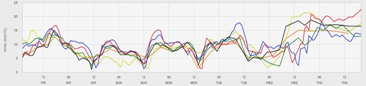
Most people have their favourite weather website based on useability and perception of accuracy. Whatever site you use I recommend you also use the PredictWind app https://www.predictwind.com/ to get a feel for the overall certainty of the forecast. Most websites provide a single “best guess” forecast. The advantage of the PredictWind format is that it shows the results of 6 different models over the forecast period. If all the models align you can be fairly confident in the forecast. Where there are large variations in the different models you need to be more careful.
And one final thing – a look out the window usually provides the best short term forecast.